Record rain slams Brevard again, and this time the beachside gets hit hardest
Melbourne set a daily rainfall record of 2.61 inches on Wednesday, less than three weeks after its all-time 24-hour mark of 11.51 inches on Nov. 2. This time, official east-side airport gauges are leading the multi-day totals. As of 1:40 p.m. EST Thursday, a Flood Warning is in effect for southeastern Brevard until 6 p.m., the St. Johns near Cocoa is at 18.28 feet, and the Weather Prediction Center's High risk outlook remains in effect through 7 a.m. Friday.
Written with AI assistance, with sources linked below.
Local Weather
Measured on Brevard's beachside by our own weather station
- Wind
- 6 mph SSW, gusts 13 mph
- Rain today
- 6.07 in
- Humidity
- 85%
- Pressure
- 30.06 inHg ↓ falling
Updated 2:29 PM ET
Our station's outlook (based on local readings, not an official forecast)
Flood Warning in effect: rain and storms on radar near Brevard now. NWS Melbourne, until 7:00 PM ET.
Based on readings to 2:29 PM ET. Rules: 3- and 12-hour pressure change, wind shift and humidity/dew point trend. For official forecasts and warnings see the National Weather Service in Melbourne.
Sun
Sunrise 6:48 AM · Sunset 5:29 PM
Moon
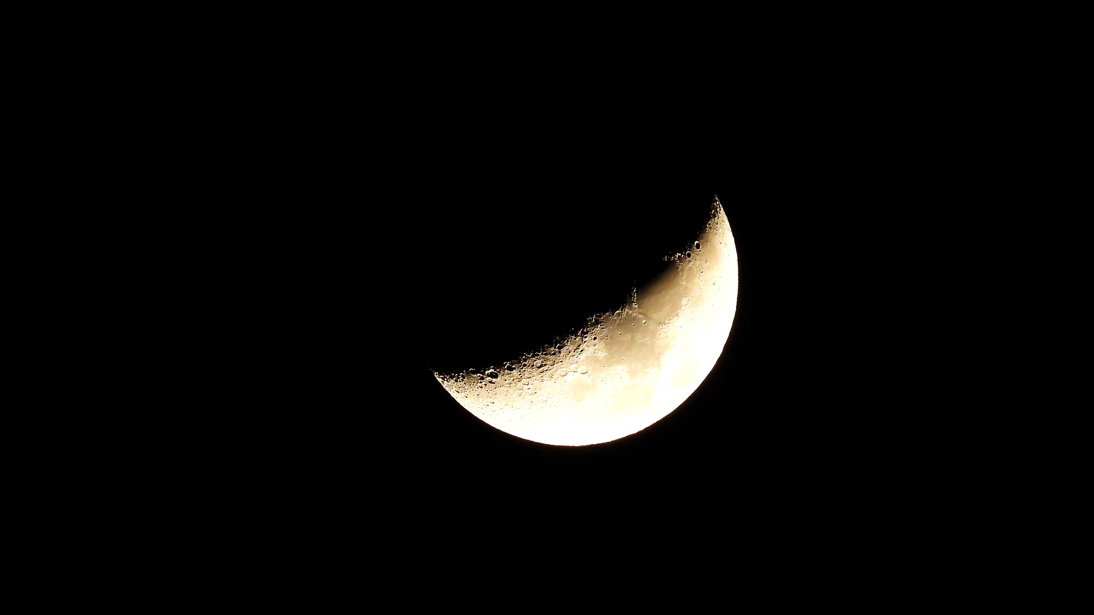
Waxing Gibbous, 74% lit
Sun and moon times are calculated on our server for Brevard's beachside. Daily weather log, records and forecast →
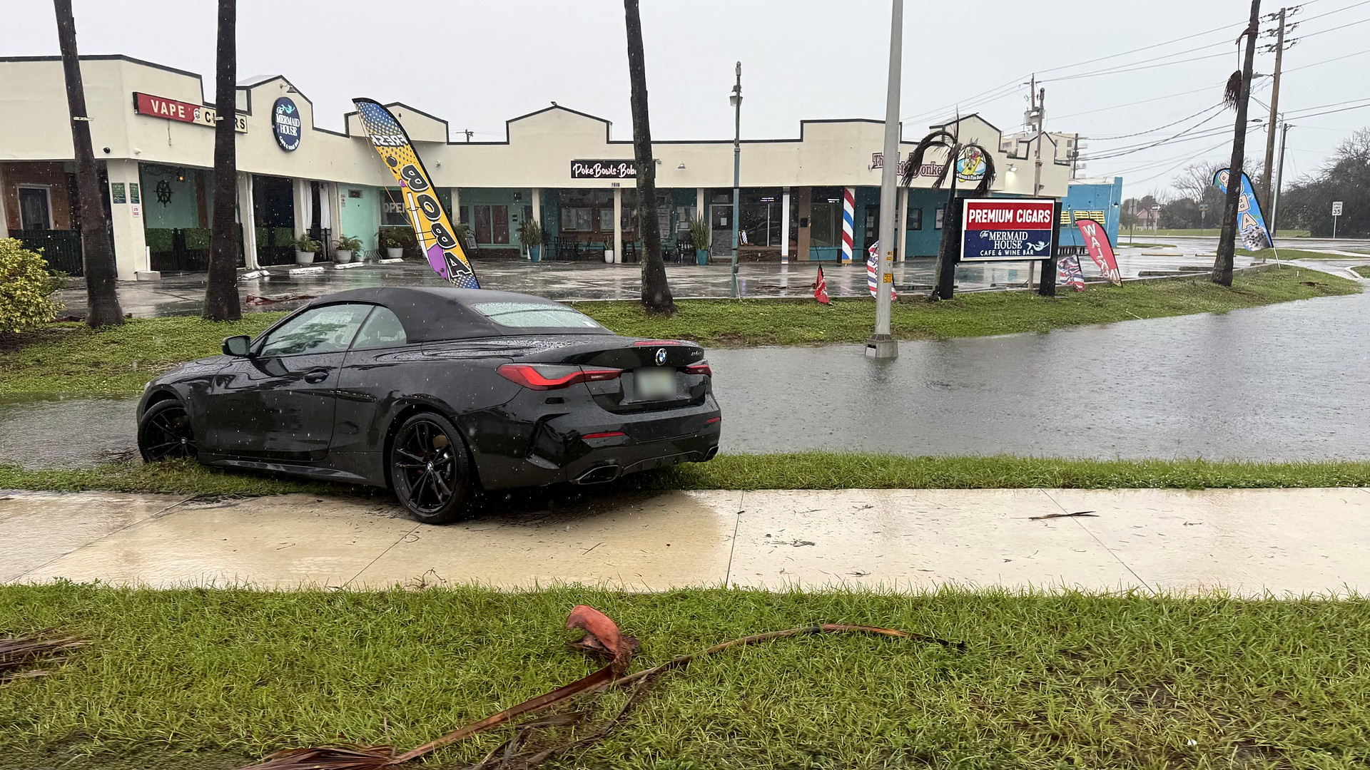
Record rain has slammed Brevard again, and official airport totals show the heaviest rain in this storm has fallen on the county's east side.
The National Weather Service official climate report for Melbourne International Airport recorded 2.61 inches on Wednesday, Nov. 18, a daily record that broke the previous mark of 0.71 inch set in 1959. That official daily record comes less than three weeks after Melbourne's all-time 24-hour rainfall of 11.51 inches on Nov. 2, a total that also set the airport's November monthly record, according to an NWS record event report from that earlier storm.
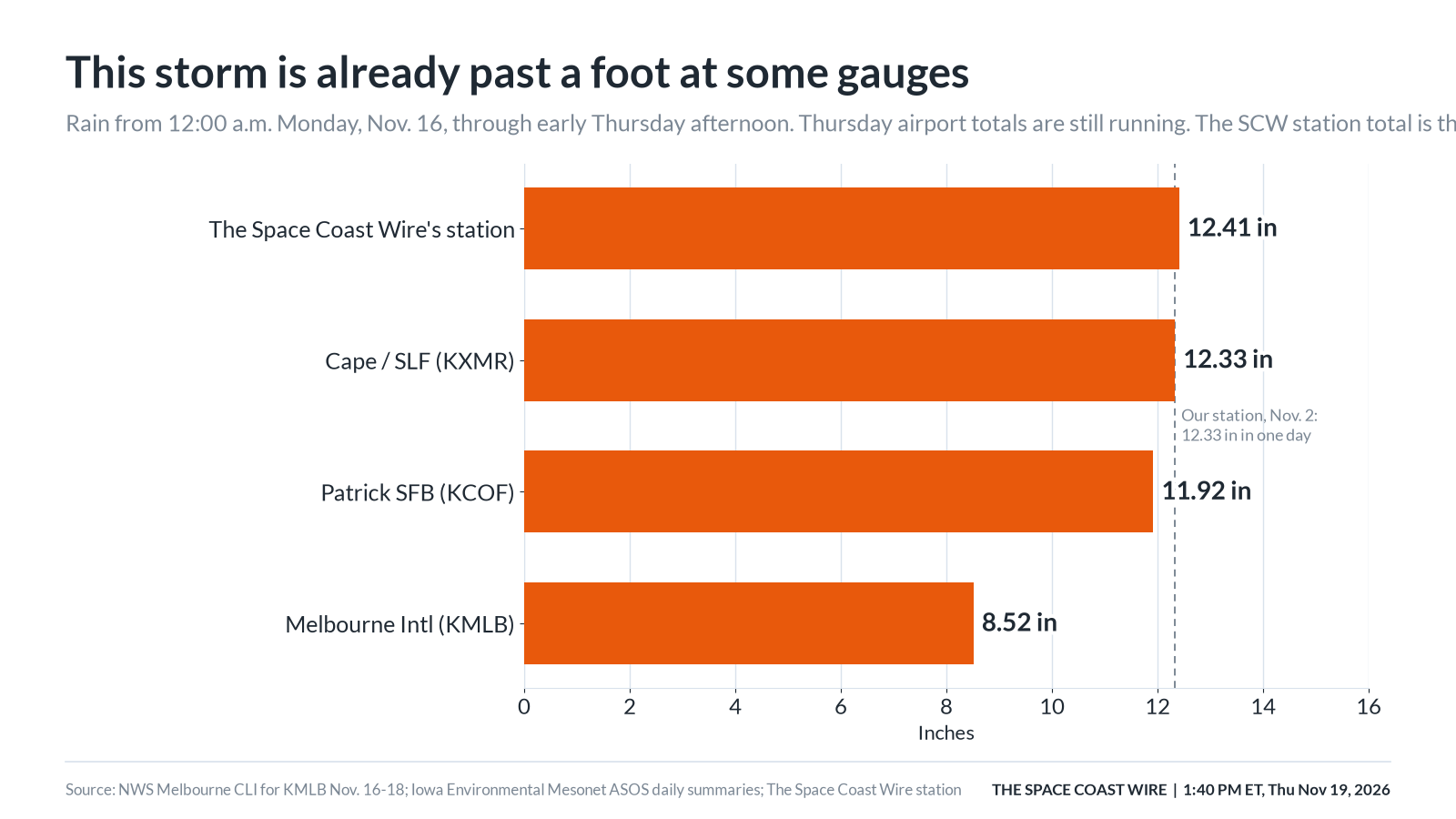
This time, the official airport gauges farther east are leading the multi-day totals. Observations compiled by the Iowa Environmental Mesonet show that from 12:00 a.m. Monday through the early Thursday afternoon download, the Shuttle Landing Facility (KXMR) on Merritt Island had 12.33 inches and Patrick Space Force Base (KCOF) had 11.92 inches, compared with 8.52 inches at Melbourne International (KMLB) on the mainland. Those two east-side gauges are also ahead of where they stood on Nov. 2, when IEM records showed 4.38 inches at the Shuttle Landing Facility and 6.41 inches at Patrick, well below Melbourne's official 11.51 inches that day. Thursday's amounts in this week's running totals are unofficial and still accumulating. Official climate numbers for Thursday have not been issued yet.
The event is not over. At 10:55 a.m. EST Thursday, Nov. 19, 2026, the Weather Prediction Center, in coordination with the National Weather Service office in Melbourne, upgraded Brevard to a High risk of excessive rainfall through 7 a.m. Friday. The discussion said water rescues were already underway, numerous streets were flooded, and water was entering homes, and that continued rain would have nowhere to go except to worsen flooding it described as already breaking all-time records. As of 1:40 p.m. EST Thursday, that 10:55 a.m. outlook was still the latest WPC product. Our breaking account of the High risk upgrade and water rescues is here: Brevard flash flooding, High risk, and water rescues.
What is in effect as of 1:40 p.m. Thursday
A Flood Watch covers Brevard and much of east central Florida from Tuesday afternoon through 7 p.m. EST Friday. NWS Melbourne first issued that watch on Monday afternoon. The watch says repeated rounds of showers and isolated storms could produce 3 to 6 inches of rain, with localized amounts of 8 to 12 inches, especially in the coastal counties.
At 1:35 p.m. EST Thursday, NWS Melbourne issued a Flood Warning for southeastern Brevard until 6 p.m. EST. The warning said flooding caused by excessive rainfall was already occurring, numerous roads remained closed, and 4 to 8 inches of rain had fallen in the warned area. Locations listed include Palm Bay, Melbourne, Malabar, West Melbourne, Melbourne Beach, Grant-Valkaria, Micco, Indialantic, and Eau Gallie. That warning follows a Flash Flood Warning for the same part of the county that had been extended at 11:29 a.m. until 1:45 p.m.
Separately, NWS Melbourne still had three Flash Flood Warnings touching Brevard as of 1:40 p.m. EST Thursday:
- Central Brevard, extended at 12:31 p.m. until 2:45 p.m. EST, with 7 to 11 inches indicated by radar and gauges and up to 2 inches more possible. Locations include Titusville, Rockledge, Cocoa, Cocoa Beach, Merritt Island, Cape Canaveral, Port St. John, Viera, Satellite Beach, Indian Harbour Beach, Melbourne, and Patrick Space Force Base.
- Northwestern Brevard and southeastern Orange County, extended at 1:07 p.m. until 3 p.m. EST, with 3 to 7 inches indicated. Locations include the Lone Cabbage Fish Camp area.
- Northwestern Brevard and eastern Volusia County, extended at 1:11 p.m. until 3 p.m. EST, with 3 to 6 inches indicated and up to 2 inches more possible. Locations on the Brevard side include Mims and Scottsmoor.
A 10:44 a.m. local storm report said parts of Port Malabar Boulevard had washed away and the road was closed.
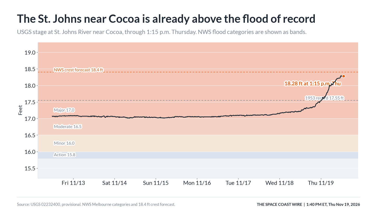
A Flood Warning remains in effect until further notice for the St. Johns River near Cocoa. NWS Melbourne said major flooding was occurring and was forecast, and that this passes the flood of record. At 8:15 a.m. Thursday the official river statement put the stage at 18.1 feet, with flood stage at 16.0 feet, bankfull at 15.8 feet, and a forecast to rise and remain near 18.4 feet. The USGS gauge, site 02232400, later read 18.28 feet at 1:15 p.m. EST. As of 1:40 p.m. EST Thursday, that 1:15 p.m. value was the latest provisional observation, and the National Weather Service river forecast page still showed a forecast of 18.4 feet at 7 p.m. EST Thursday. Our earlier story on flooding along the St. Johns near Cocoa and in the Lake Poinsett area is here: St. Johns River near Cocoa and Lake Poinsett.
NWS impact language for 17.2 feet, a level the river has already gone past, says water enters homes along the St. Johns in the Lake Poinsett area west of Cocoa, low-lying homes in the Silver Pines subdivision in Rockledge, and the Shakespeare Park area of Cocoa; that the Providence Road area west of Cocoa becomes impassable, cutting off access to homes in the Mullet Lane and Bass Road area; and that docks flood and water reaches the parking lot at Lone Cabbage Fish Camp.
A High Surf Advisory and a High Rip Current Risk remain in effect for Brevard's mainland and barrier beaches until 7 p.m. EST Saturday. NWS Melbourne warns of rough, pounding surf, moderate to locally major beach erosion, and numerous strong, life-threatening rip currents, and says entering the surf is strongly discouraged. A Wind Advisory for Brevard, updated at 9:01 a.m. Thursday, remains in effect until 7 p.m. EST this evening.
County and city notices, damage, and federal aid
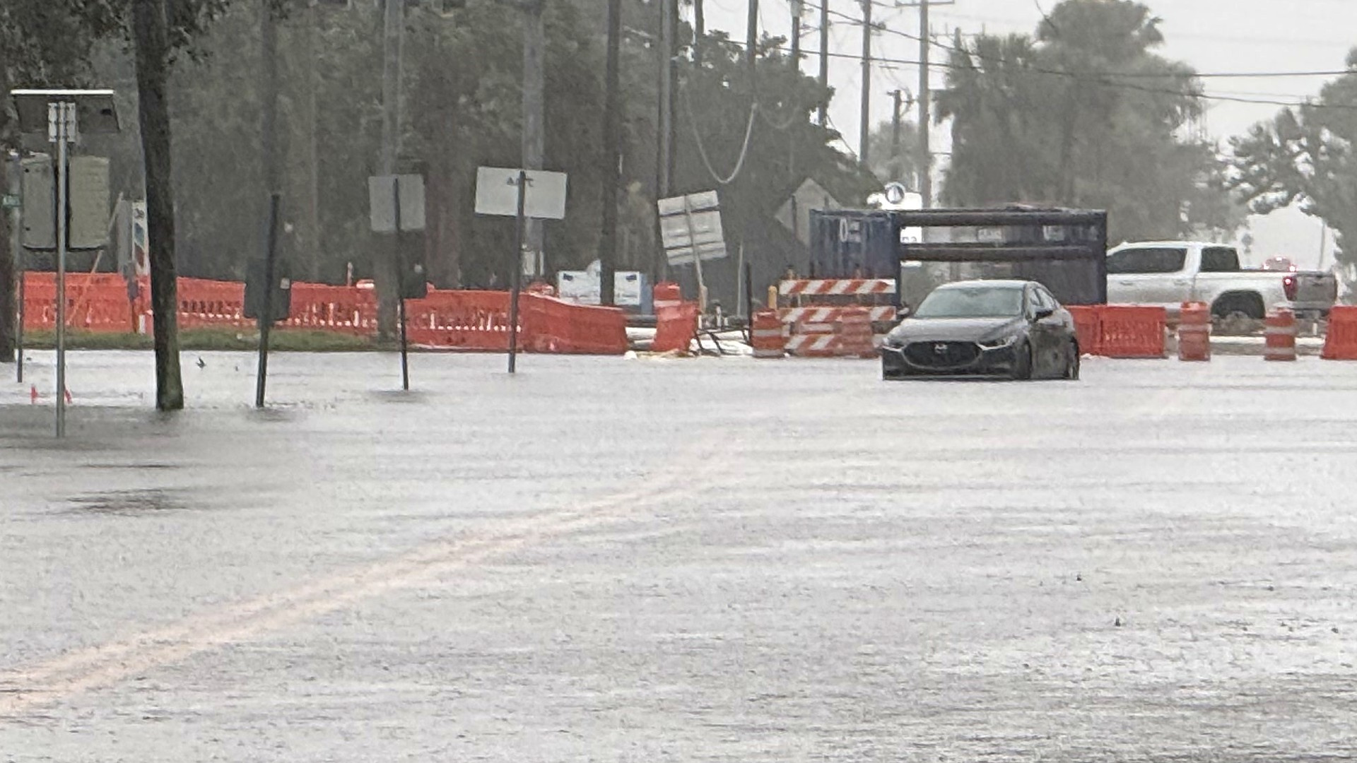
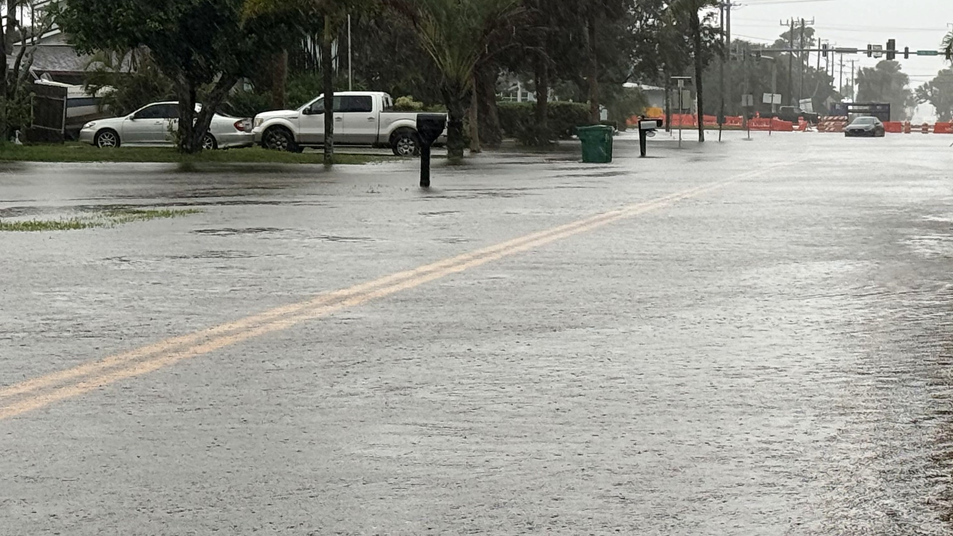
The City of Melbourne, in an 8:45 a.m. Thursday update, said a flash flood warning was in effect and asked people to stay home and stay off the roads if they could. Melbourne police, in an 8:30 a.m. traffic update, said officers were already seeing cars stuck in floodwaters, that the intersection of Commodore Boulevard and Aurora Road was seeing significant flooding, and that Florida Avenue west of Babcock Street was flooded. The city said Brevard County's sandbag distribution had ended, and that residents can buy bags at home improvement stores and fill them with dirt from their property, or use bagged dirt, mulch, or playground sand. It is illegal to fill sandbags with sand from the beach.
WESH, citing FL 511 and the Florida Highway Patrol at 11:19 a.m. EST Thursday, listed additional Brevard road closures or partial shutdowns because of flooding, including Dairy Road southbound at Hibiscus Boulevard, U.S. 1 at several points, State Road 520 westbound near Ridgeway Avenue, Sarno Road at North Drive, State Road A1A at Shearwater Parkway, State Road 404 eastbound at Patrick Drive, Eau Gallie Boulevard at Riverside Drive, and stretches of U.S. 192. Those listings should be checked against current FL 511 and local traffic pages before travel, because closures change quickly.
Brevard County's Storm Center page has, during this event, listed a shelter at the Walter Butler Community Center, 4201 N. Cocoa Blvd., Cocoa, open to the general population, people with special medical needs, and families with pets, and has listed free sandbag sites that were operating Wednesday. The city of Melbourne said Thursday morning that the county sandbag distribution had ended. The county website returned an access error to our fetcher this morning, so readers should confirm shelter and sandbag status on the county Storm Center page or by calling 2-1-1.
The City of Palm Bay has ordered a mandatory evacuation for part of Palm Bay Estates because of flooding, according to our live coverage, which cites Spectrum News 13, WFTV, and WKMG News 6 reporting on the city's order. Those accounts said the order covers homes west of the canal and east of the railroad tracks, and WKMG reported the city said 65 homes are affected. Our story is here: Palm Bay Estates mandatory flood evacuation.
Brevard Public Schools closed all campuses and district offices on Thursday, Nov. 19, and will stay closed Friday, Nov. 20, because of the flooding. Our live story, which cites WFTV and Florida Today, is here: Brevard Public Schools closed Friday. WFTV reported that, with Fall Break already scheduled for Nov. 23 to 27 on the district website, students and employees are not due back until Monday, Nov. 30.
WFTV reported Thursday that the Florida Division of Emergency Management is coordinating a statewide deployment amid the flooding, including hundreds of Florida National Guard and Florida State Guard personnel, more than 200 Florida Highway Patrol troopers, 235 Florida Fish and Wildlife Conservation Commission officers, 50 high-water vehicles, and 60 pumps. The report was not limited to Brevard. WFTV's account is here: Florida National Guard and State Guard deployed amid flooding.
FEMA's public major-disaster records, retrieved this morning, show no approved federal major disaster declaration for Brevard for the November flooding. The only recent Florida declarations in that dataset are for Hurricane Isaias. Florida has already submitted a request for the earlier November flood, and Brevard emergency officials have said that request still has to be approved before FEMA Individual Assistance opens. That pending request is for the earlier flood, not a new declaration tied only to this week's rain. Residents who need local help can call 2-1-1. Businesses that had losses in the fall flooding can still use the state survey at FloridaDisaster.biz, selecting "2026 Fall Flooding."
Separate official and news accounts of the Nov. 2 flood, including displacement at the Windover Palms apartments in Melbourne, describe harm from that earlier event and should not be read as new, independently confirmed totals for this week's rain alone.
How much rain has already fallen
NWS Melbourne has not issued a storm-total public information statement for this Nov. 16-19 event as of late Thursday morning. The figures below are official daily climate totals where they exist, airport observations compiled by the Iowa Environmental Mesonet, warning-scale reports from NWS, and The Space Coast Wire's own station. Thursday airport numbers are still running and will not be final until the next climate report.
At Melbourne International Airport (KMLB), the official NWS climate reports recorded 0.61 inch on Monday, Nov. 16; 0.34 inch on Tuesday, Nov. 17; and 2.61 inches on Wednesday, Nov. 18. That Wednesday total set a daily record, breaking 0.71 inch from 1959, according to an NWS record event report issued at 2:42 a.m. Thursday. The same official climate package put Melbourne's month-to-date rainfall at 17.25 inches through Nov. 18, a figure that does not include Thursday. IEM's running total for Thursday at KMLB was 4.96 inches as of the early afternoon download, which would bring the four-day airport total to 8.52 inches if that running figure holds. Official climate numbers for Thursday have not been issued yet.
At Patrick Space Force Base (KCOF), IEM's ASOS daily summaries show 0.28 inch Monday, 0.68 inch Tuesday, 2.15 inches Wednesday, and a running 8.81 inches Thursday, or 11.92 inches since Monday. At the Shuttle Landing Facility (KXMR), the same source shows 0.10, 0.80, 4.66, and a running 6.77 inches, or 12.33 inches since Monday. Those two east-side airport totals are leading Melbourne International in this event. Titusville Airport (KTIX) had no usable daily precipitation in those summaries for any of the four days, so we cannot report an official Titusville airport storm total from that record.
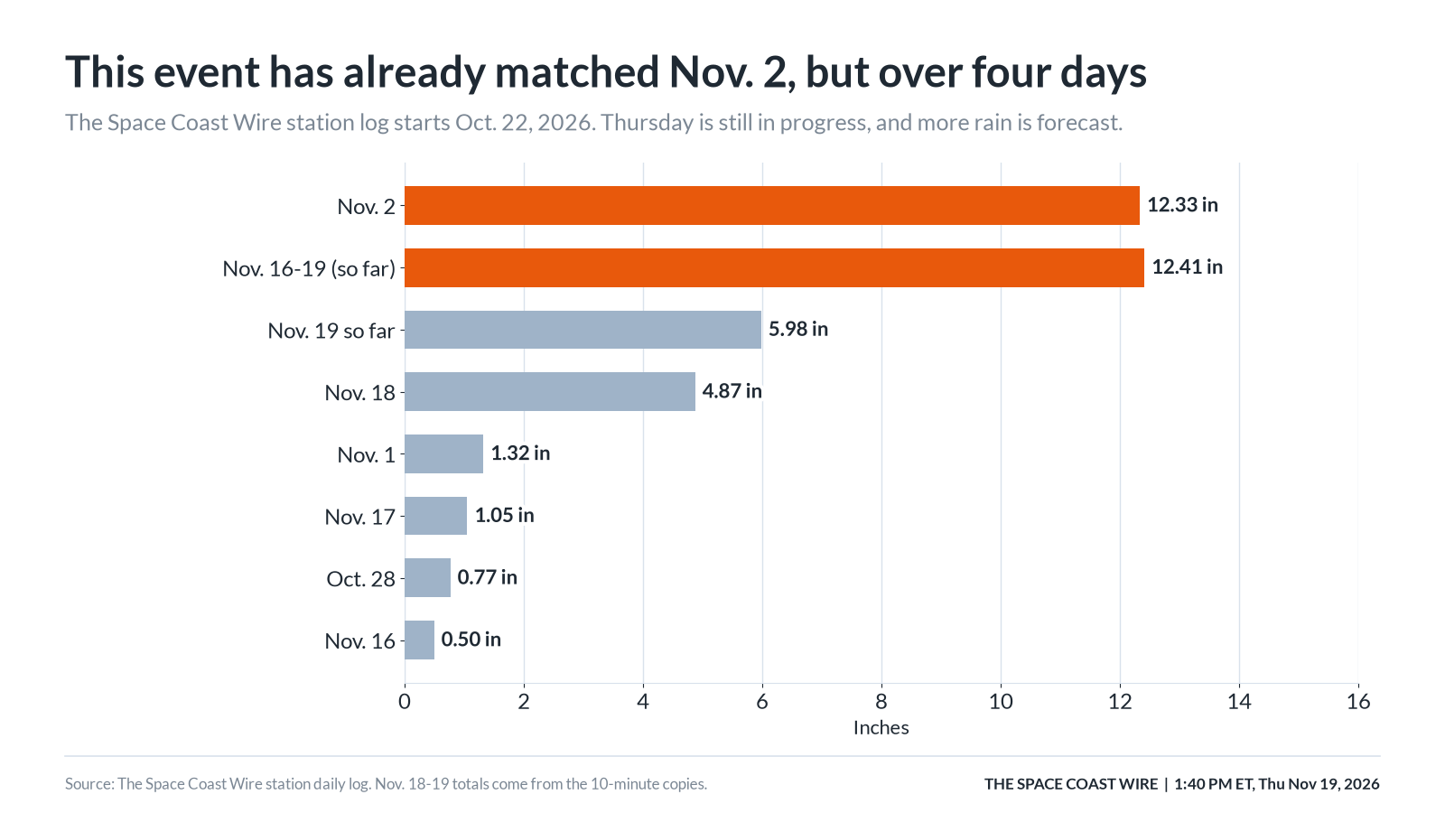
The Space Coast Wire's station, labeled only as being in Brevard, measured 0.50 inch Monday, 1.05 inches Tuesday, 4.87 inches Wednesday, and 5.98 inches from midnight to 11:44 a.m. Thursday, for 12.41 inches since 12:00 a.m. Monday. The station's own event and week counters at that time both read 12.45 inches.
Those point totals do not cover every popular area of the county. For neighborhoods without a verified gauge in this pass, the best official snapshot is the warnings themselves: 7 to 11 inches indicated in central Brevard as of 12:31 p.m., and 4 to 8 inches in southeastern Brevard as of the 1:35 p.m. Flood Warning. We were not able to pull a clean CoCoRaHS Brevard table or SJRWMD storm-total list this morning. Those sources should be added when the next NWS precipitation statement or a successful CoCoRaHS and water-management export is in hand.
What our station shows about this storm
This section uses only The Space Coast Wire's station record. The public stations page presents one weather station, not a second set of town-by-town rain gauges. The 10-minute record from midnight Monday through 11:44 a.m. Thursday has no gaps longer than 20 minutes. Wednesday and Thursday daily totals were rebuilt from those 10-minute copies.
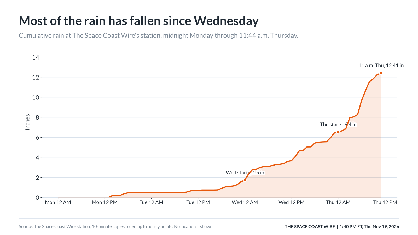
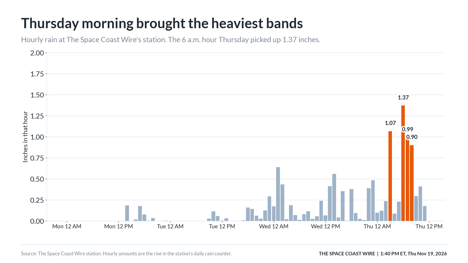
The rain did not arrive all at once. Through Tuesday evening the station had only about 1.5 inches from this event. Wednesday added 4.87 inches in repeated bands, including a 60-minute stretch from 1:14 to 2:14 a.m. that put down 0.87 inch. Thursday was heavier still. From 3:04 to 3:54 a.m., the station recorded 1.02 inches, with a peak 10-minute rate of 1.78 inches per hour. After a short lull, the main morning burst ran from 5:44 to 8:24 a.m. and put down about 3.09 inches. The single highest 10-minute rate was 2.60 inches per hour at 6:14 a.m., when 0.43 inch fell in 10 minutes. The 6 a.m. hour as a whole had 1.37 inches, the wettest hour of the event in this record. By 11:44 a.m. Thursday, the storm total at the station was 12.41 inches and rain was still falling, though the late-morning rates were lower than the dawn burst.
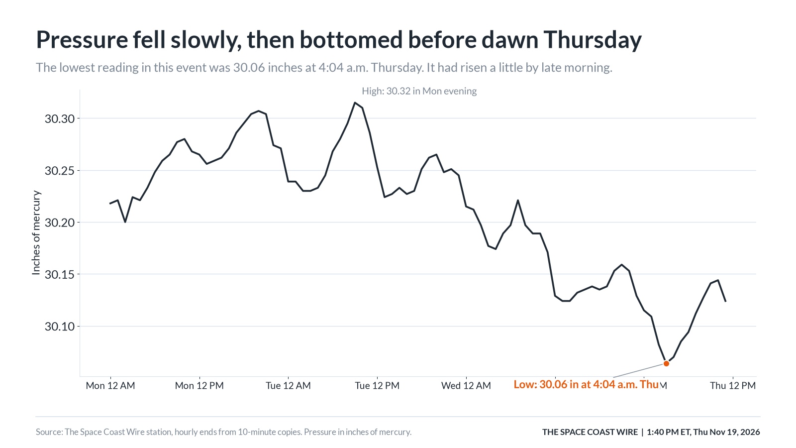
Pressure fell only slowly. The station's highest reading in the event was 30.32 inches Monday evening. The lowest so far was 30.06 inches at 4:04 a.m. Thursday, a drop of 0.17 inch from late Sunday. The fastest three-hour fall in this record was 0.09 inch between late Tuesday morning and early Tuesday afternoon. That is not a sharp crash. After the 4:04 a.m. low, pressure rose to 30.12 inches by 11:44 a.m. The National Hurricane Center and NWS Melbourne still expect a low to form near the northwest Bahamas on Friday, so this morning's small bounce should not be read as the system having already moved away.
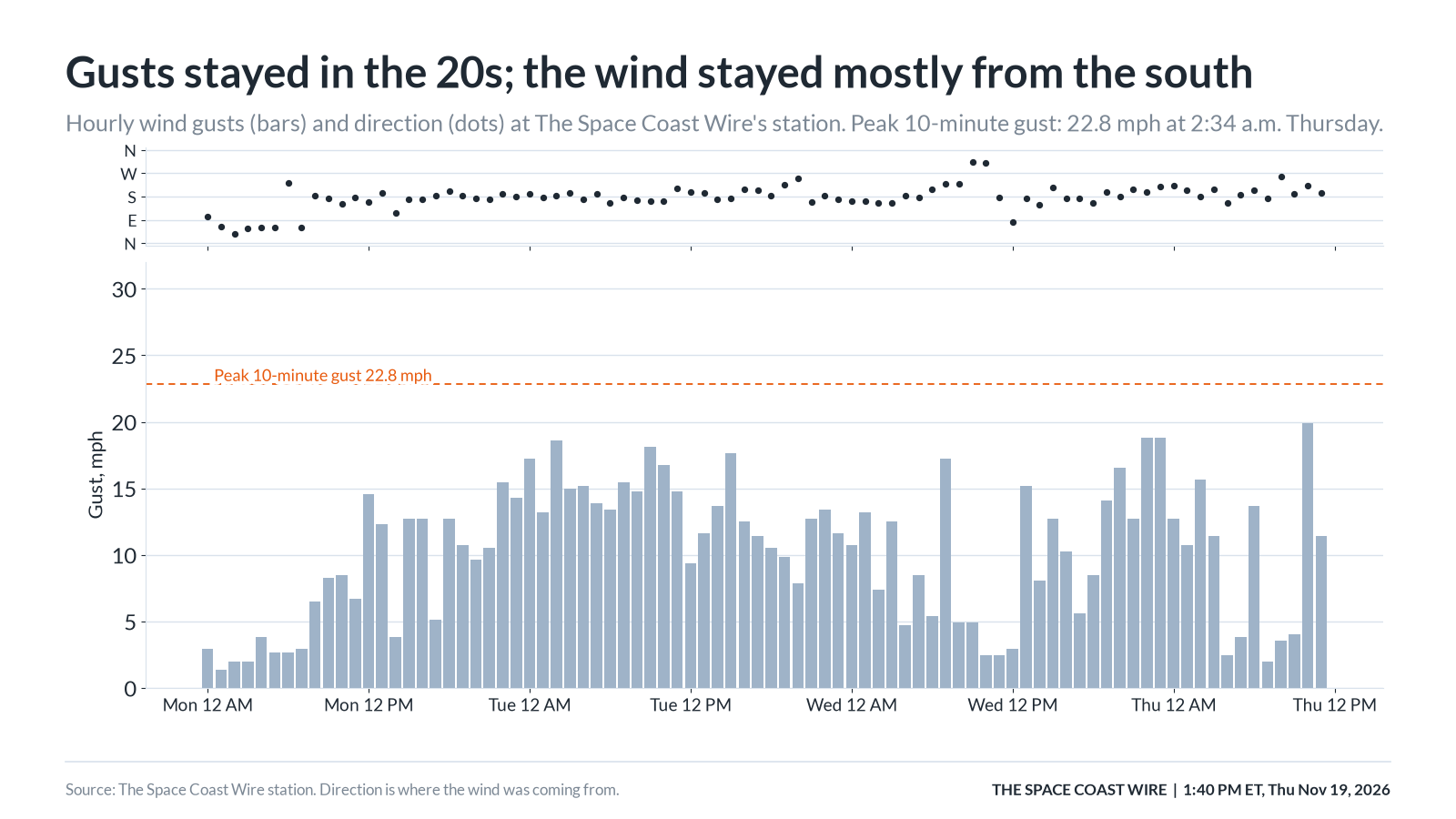
The wind at our station stayed mostly from the south or south-southwest after Monday morning, with hourly gusts generally in the teens and a peak 10-minute gust of 22.8 mph at 2:34 a.m. Thursday from the south-southwest. The daily log lists a Wednesday peak of 24.8 mph, which may have occurred between the 10-minute snapshots. Those inland-station gusts are weaker than the coastal winds NWS Melbourne has been warning about. A late-morning METAR at Patrick Space Force Base reported a peak wind of 30 knots, about 35 mph, from the southeast, and the Shuttle Landing Facility was also breezy. The official forecast still has winds turning northeast to north Friday afternoon into Saturday morning, then northwest to west Saturday evening. Our station has not yet shown that later shift.
The station log we hold starts Oct. 22, 2026, so the comparison is only to that stretch. In that log, Nov. 2 remains the wettest single day, at 12.33 inches. This week's event has already reached 12.41 inches, but it has taken four days, and Thursday is not finished. Thursday is already the second-wettest calendar day in the log, at 5.98 inches by late morning, ahead of Wednesday's 4.87 inches. The station's November month-to-date total was about 26.2 inches as of 11:44 a.m. Thursday, counting both this event and the earlier November flood.
From our GOES-19 dish
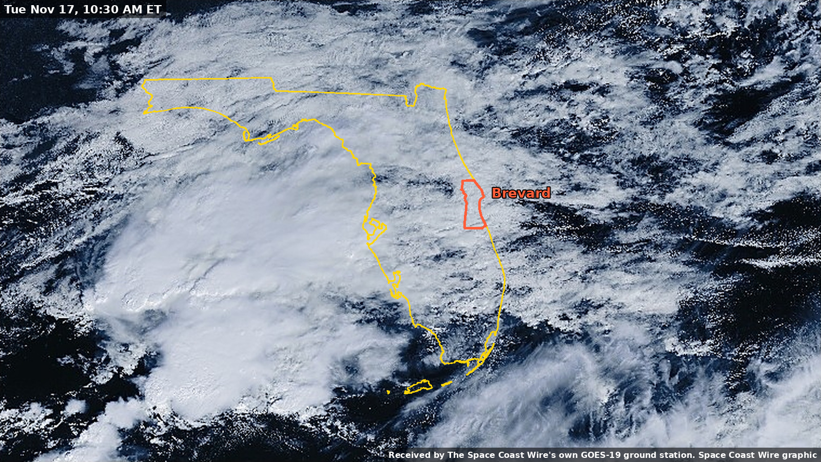
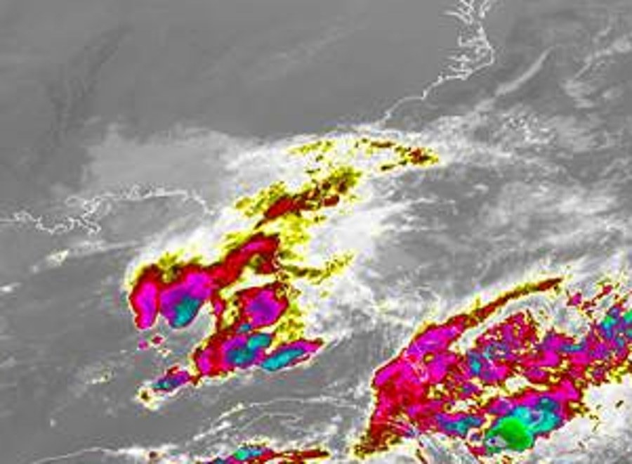
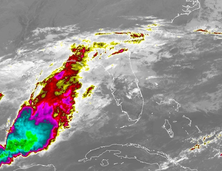
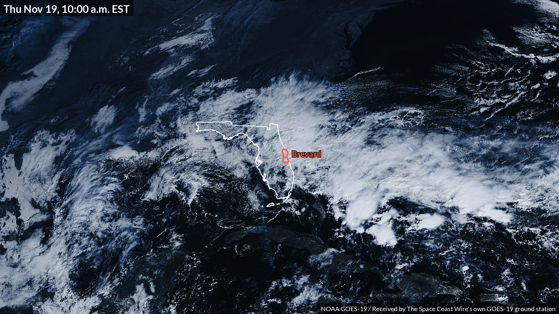
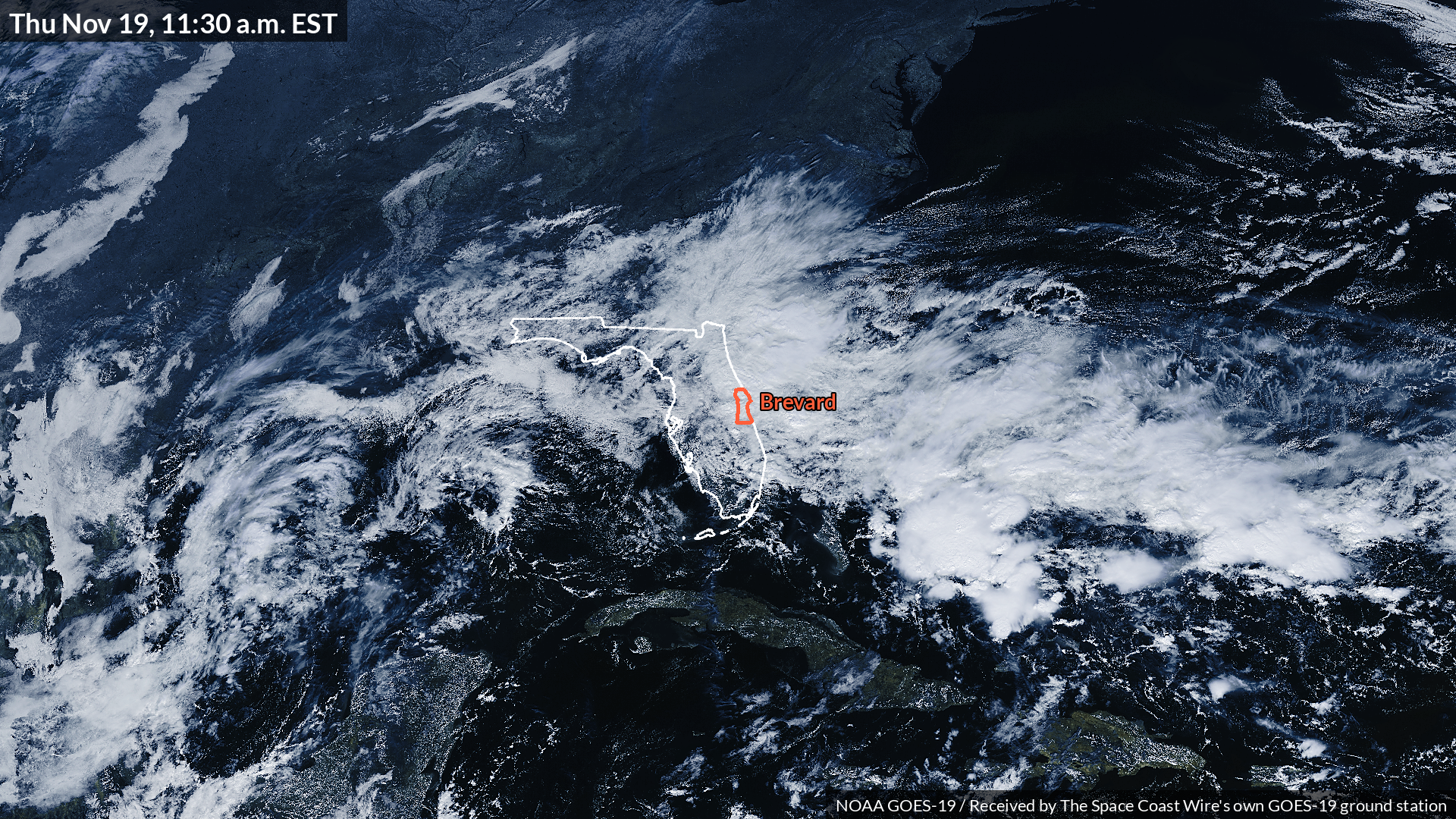
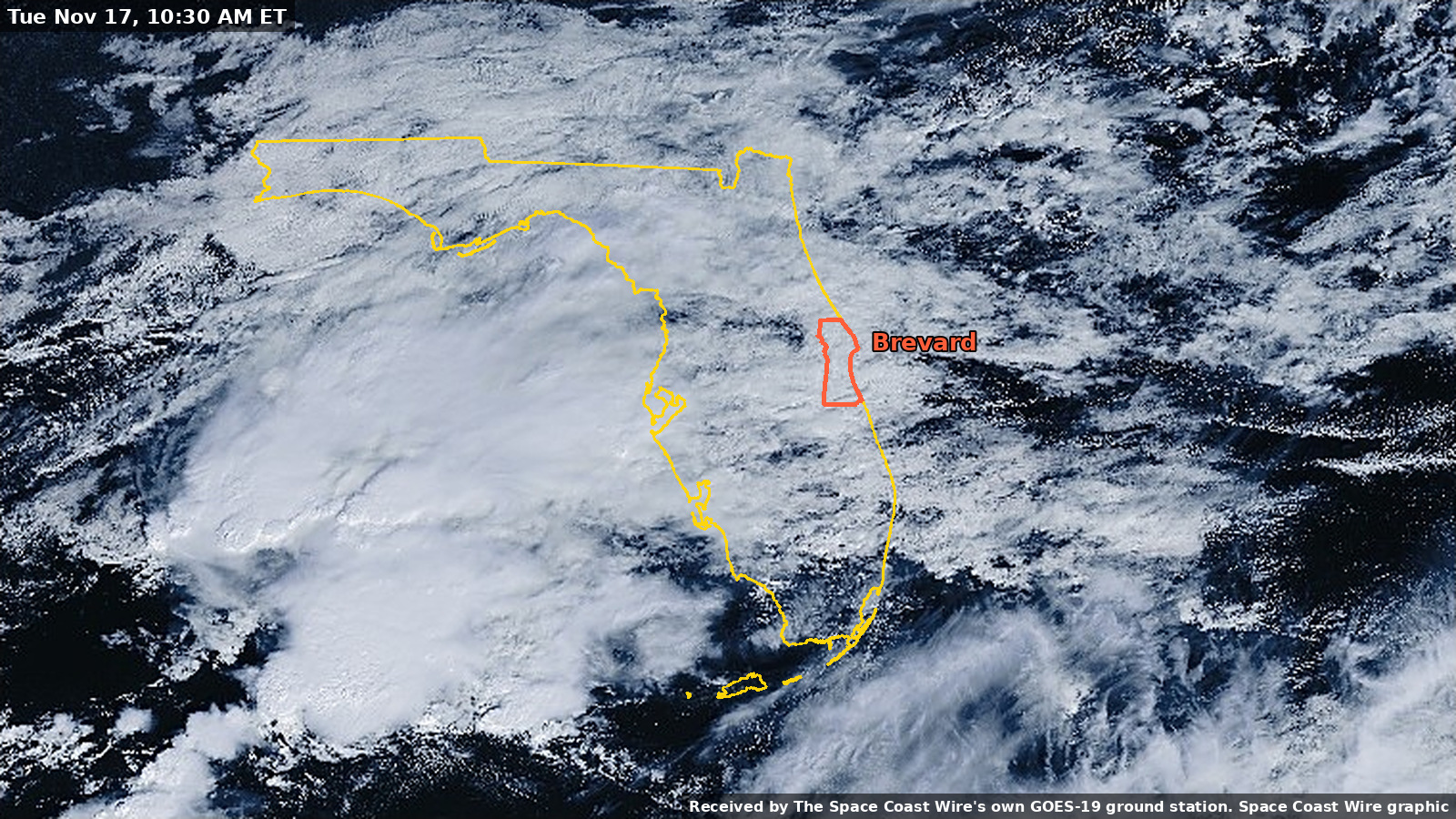
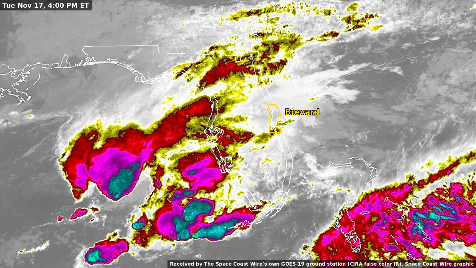
The imagery below was received on The Space Coast Wire's own GOES-19 ground station and cropped at native resolution from the full-size originals, not from images that were shrunk and then enlarged. The frames are 1920 by 1080 pixels. True-color stills from 10:00 a.m. and 11:30 a.m. Thursday show the rain shield still draped over Florida late this morning. Earlier true-color and infrared frames from Tuesday are included for context. The silent infrared time-lapse runs from 12:00 a.m. EST Monday, Nov. 16, through 11:30 a.m. EST Thursday, Nov. 19, at 10 frames per second, with a short hold on the final frame.
The NWS forecast: what to expect, and when the rain eases
This is the National Weather Service forecast, not a Space Coast Wire forecast.
NWS Melbourne's 12:39 p.m. EST Thursday Area Forecast Discussion said a Flood Watch remains in effect almost areawide through Friday. The office said 3 to 6 inches had already fallen near the coast from Indian River County north through Brevard and Volusia, and that an additional 4 to 8 inches was possible through Friday night in some of those same places, with isolated 15 inches or more within reach, especially near the coast. Rain chances were listed as numerous, 60 to 100 percent, through Friday, with repeated torrential downpours, isolated lightning, and gusts locally 30 to 45 mph.
The same discussion said rain chances decrease to scattered, 25 to 50 percent, on Saturday, with drier conditions Sunday into Monday. Scattered showers may return Tuesday and Wednesday. That is the office's current timing for when the heaviest rain eases, not a guarantee that every shower ends at dawn Saturday.
There is an important caveat, and NWS Melbourne stated it plainly. A low is forecast to form near or over the northern Bahamas on Friday. The National Hurricane Center's 7 a.m. EST Thursday Tropical Weather Outlook gave that system a 20 percent chance of becoming a subtropical or tropical storm within 48 hours, and a 60 percent chance within seven days, as it moves north or northeast near or just off the southeastern U.S. coast through the weekend. NWS Melbourne said a track closer to the coast would increase rainfall and wind threats, and a track farther offshore could wrap drier air into the area this weekend. Until the low forms and has a trackable center, the office said specific impacts are not known with much confidence. The Hurricane Center also warned that, regardless of development, strong winds, dangerous surf, and coastal flooding are likely along portions of the southeast and mid-Atlantic coasts into early next week.
The Weather Prediction Center's later 10:55 a.m. outlook is more urgent for today and tonight: a High risk of excessive rainfall for Brevard through 7 a.m. Friday, then a Moderate risk for portions of eastern and central Florida from 7 a.m. Friday to 7 a.m. Saturday. That Day 2 discussion said backing flow should slowly ease heavy rain concerns Friday night and early Saturday, which lines up with Melbourne's Saturday decrease in rain chances. Saturday's Day 3 outlook is a broader Slight risk along the Southeast coast, with uncertainty about how close the low tracks to land. As of 1:40 p.m. EST Thursday, that 10:55 a.m. WPC outlook was still the latest Excessive Rainfall Discussion.
For the river, NWS Melbourne and the Southeast River Forecast Center expected the St. Johns near Cocoa to crest near 18.4 feet around 7 p.m. EST Thursday and to hold near 18.4 feet through the five-day forecast, which runs into Tuesday. As of 1:40 p.m. EST Thursday, the official river forecast page still showed that 18.4-foot forecast at 7 p.m. Thursday. In other words, the official river forecast does not show a quick fall after tonight's crest. Upstream at Geneva, the same forecast package called for a rise into major flooding, with a crest near 12.3 feet around 1 p.m. EST Sunday. Additional rain can change those crests. The latest official river forecasts are at water.noaa.gov/wfo/MLB.
Do not drive through floodwaters. Turn around if a road is covered or barricaded.
Sources
- NWS Melbourne Area Forecast Discussion, 12:39 p.m. EST Thu Nov. 19
- NWS Melbourne Flood Watch
- Active NWS alerts
- NWS Melbourne Flood Warning for the St. Johns River near Cocoa
- USGS 02232400, St. Johns River near Cocoa (provisional)
- NWS Melbourne climate report and record event report for KMLB
- Iowa Environmental Mesonet ASOS daily summaries
- Weather Prediction Center Excessive Rainfall Discussion, 10:55 a.m. EST Thu Nov. 19
- National Hurricane Center Tropical Weather Outlook, 7 a.m. EST Thu Nov. 19
- City of Melbourne, Nov. 19, 8:45 a.m. update
- Brevard County Storm Center
- WESH road closures report, citing FL 511 and FHP
- OpenFEMA disaster declarations
- FloridaDisaster.biz business damage survey
- The Space Coast Wire station daily log and 10-minute copies, values only, no location
- Brevard flash flooding, High risk, and water rescues
- St. Johns River near Cocoa and Lake Poinsett
- National Weather Service NWPS gauge page for COCF1, retrieved 1:40 p.m. EST Thu Nov. 19
- Palm Bay Estates mandatory flood evacuation
- Brevard Public Schools closed Friday
- WFTV, Florida National Guard and State Guard deployed amid flooding
- Related earlier coverage: How The Space Coast Wire's Weather Station Network Sees This Storm
Sources
- NWS Melbourne Area Forecast Discussion, 12:39 p.m. EST Thu Nov. 19 forecast.weather.gov/product.php?site=MLB&issuedby=MLB&product=AFD&format=txt&version=1&glossary=0
- NWS Melbourne Flood Watch forecast.weather.gov/showsigwx.php?warnzone=FLZ747&warncounty=FLC009
- Active NWS alerts api.weather.gov/alerts/active?zone=FLC009
Show all 21 sourcesShow fewer
- NWS Melbourne Flood Warning for the St. Johns River near Cocoa water.noaa.gov/gauges/cocf1
- USGS 02232400, St. Johns River near Cocoa (provisional) waterdata.usgs.gov/monitoring-location/02232400/
- NWS Melbourne climate report and record event report for KMLB forecast.weather.gov/product.php?site=MLB&issuedby=MLB&product=CLI&format=txt&version=1&glossary=0
- Iowa Environmental Mesonet ASOS daily summaries mesonet.agron.iastate.edu/
- Weather Prediction Center Excessive Rainfall Discussion, 10:55 a.m. EST Thu Nov. 19 www.wpc.ncep.noaa.gov/#page=ero
- National Hurricane Center Tropical Weather Outlook, 7 a.m. EST Thu Nov. 19 www.nhc.noaa.gov/gtwo.php?basin=atlc&fdays=7
- City of Melbourne, Nov. 19, 8:45 a.m. update www.melbourneflorida.org/News-articles/November-19-Morning-Update
- Brevard County Storm Center www.brevardfl.gov/StormCenter
- WESH road closures report, citing FL 511 and FHP www.wesh.com/article/road-closures-flooding-central-florida-brevard-county/74475372
- OpenFEMA disaster declarations www.fema.gov/disaster/declarations
- FloridaDisaster.biz business damage survey www.FloridaDisaster.biz
- Brevard flash flooding, High risk, and water rescues spacecoastwire.com/story/brevard-flash-flooding-high-risk-water-rescues-nov-19
- St. Johns River near Cocoa and Lake Poinsett spacecoastwire.com/story/st-johns-river-cocoa-moderate-flooding-lake-poinsett-nov-2
- National Weather Service NWPS gauge page for COCF1, retrieved 1:40 p.m. EST Thu Nov. 19 api.water.noaa.gov/nwps/v1/gauges/COCF1
- Palm Bay Estates mandatory flood evacuation spacecoastwire.com/story/palm-bay-estates-mandatory-flood-evacuation-nov-19
- Brevard Public Schools closed Friday spacecoastwire.com/story/brevard-public-schools-closed-friday-flooding-nov-20
- WFTV, Florida National Guard and State Guard deployed amid flooding www.wftv.com/news/local/florida-deploys-national-guard-state-guard-amid-widespread-flooding/4SGFJGOWYRGYVP3YX5VRMSLFH4/
- How The Space Coast Wire's Weather Station Network Sees This Storm spacecoastwire.com/story/how-scw-weather-station-network-sees-this-storm
Spot something wrong? Request a correction · Our standards
Comments
Keep it friendly. Rude, hostile or personal-attack comments will be removed.