Major flooding holds on St. Johns as storms return Wednesday and the season's coolest air arrives this weekend
NWS Melbourne says the St. Johns west of Cocoa remains near major flood stage this week, while showers and a few storms return Wednesday and the coolest air of the fall arrives over the weekend. A high rip current risk continues at Brevard beaches, and NHC expects no tropical development in the next 7 days.
Written with AI assistance, with sources linked below.
Local Weather
Measured on Brevard's beachside by our own weather station
- Wind
- 0 mph N, gusts 2 mph
- Rain today
- 0.00 in
- Humidity
- 70%
- Pressure
- 29.93 inHg → steady
Updated 6:47 AM ET
Our station's outlook (based on local readings, not an official forecast)
Flood Warning in effect: rain on radar near Brevard now. NWS Melbourne, until 12:00 PM ET.
Based on readings to 6:47 AM ET. Rules: 3- and 12-hour pressure change, wind shift and humidity/dew point trend. For official forecasts and warnings see the National Weather Service in Melbourne.
Sun
Sunrise 6:43 AM · Sunset 5:32 PM
Moon
Waxing Crescent, 10% lit
Sun and moon times are calculated on our server for Brevard's beachside. Daily weather log, records and forecast →
This story reflects NWS Melbourne and National Hurricane Center products checked the evening of Monday, Nov. 9, 2026. For official forecasts and warnings, see weather.gov.
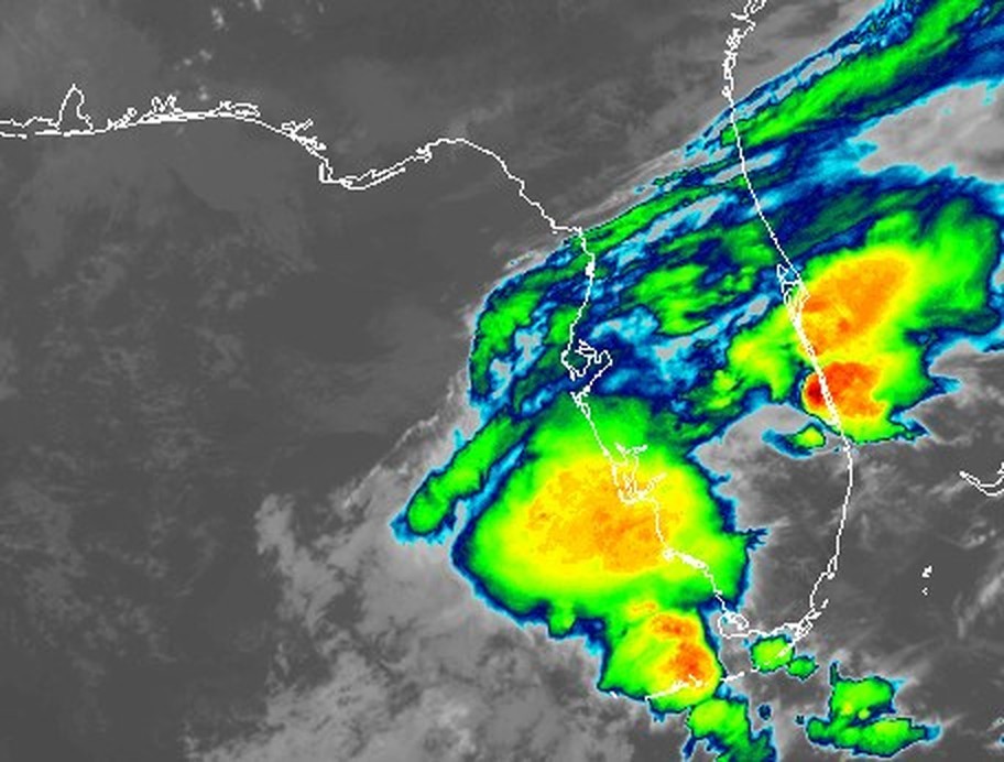
Dry, mostly sunny weather settled over east-central Florida on Monday after last week's exceptional rainfall, but the St. Johns River remains high, storms are forecast to return midweek, and the coolest air of the fall is on the way this weekend, according to the National Weather Service in Melbourne.
St. Johns River: major flooding near Cocoa
An NWS Melbourne Flood Warning issued at 9:22 a.m. EST Monday for the St. Johns River near Cocoa remains in effect until further notice. NWS said: "Major flooding is occurring and major flooding is forecast." It reported: "At 8:15 AM EST Monday the stage was 17.0 feet." Flood stage is 16.0 feet. The weather service said: "The river is forecast to remain steady just at Major flood stage through this week."
NWS listed this impact at 17.2 feet: "Water enters homes along the St Johns River in the Lake Poinsett area west of Cocoa, also low lying homes in the Silver Pines subdivision in Rockledge and the Shakespeare Park area of Cocoa. Providence Road area west of Cocoa becomes impassable, cutting off access to homes in the Mullet Lane and Bass Road area. Docks flooded and water in parking lot at Lone Cabbage Fish Camp."
The National Water Prediction Service gauge west of Cocoa (COCF1) read 16.99 feet at 5:15 p.m. EST Monday, just under the 17.0-foot major flood threshold. The Southeast River Forecast Center forecast issued Monday afternoon keeps the river near 17.0 to 17.2 feet through Saturday morning. The next NWS statement on the Cocoa gauge is due Tuesday at 11:30 a.m. EST.
For the running local record on this river rise, see our story: St. Johns River near Cocoa reaches major flood stage, NWS expects it to hold there this week.
Upstream, an NWS Flood Warning for the St. Johns above Lake Harney said moderate flooding is occurring. The gauge was at 9.1 feet at 11:30 a.m. Monday; the NWPS reading was 9.12 feet mid-afternoon. NWS said: "River levels have the potential to approach Major flood stage next weekend." In its 3 p.m. Area Forecast Discussion, NWS Melbourne also said the Geneva gauge is forecast to approach major flood stage by the weekend.
Farther north in Seminole County, the St. Johns near Sanford was at 5.4 feet Monday morning and 5.37 feet by mid-afternoon on the NWPS gauge, still below its 5.5-foot flood stage. An NWS Flood Warning said the river is forecast to rise above flood stage early Thursday morning and reach 5.5 feet.
Midweek storms, then the coolest air of the fall
NWS Melbourne's Area Forecast Discussion issued at 2:59 p.m. EST Monday (key messages at 3 p.m.) said tranquil, seasonable weather continues through Tuesday aside from patchy morning fog. Then: "Scattered to numerous showers and a few storms return on Wednesday; the potential exists for isolated strong storms." The discussion said those storms could bring lightning, wind gusts of 40 to 55 mph, small hail and heavy rainfall of up to 1 to 3 inches in 60 minutes.
A cold front follows late in the week. NWS said: "The coolest air so far this autumn season is expected to arrive this weekend." From Greater Orlando and north, the office put a 30 to 40 percent chance of wind chills reaching the upper 30s Saturday and Sunday morning.
Beaches and tropics
"A High Risk of life-threatening rip currents continues at Atlantic beaches of Central Florida," NWS Melbourne said in the same afternoon discussion. A Rip Current Statement covering Brevard's mainland and barrier-island beaches remains in effect through late Monday night. NWS advises people not to enter the surf while the high risk continues.
The National Hurricane Center's Tropical Weather Outlook issued at 1 p.m. EST Monday said: "Tropical cyclone formation is not expected during the next 7 days."
For official forecasts and warnings, see weather.gov.
Sources
- NWS Melbourne Flood Warning, St. Johns River near Cocoa (API), Nov. 9, 2026, 9:22 a.m. EST api.weather.gov/alerts/urn:oid:2.49.0.1.840.0.1cd7f27364f3548489b2423ca62e99b48c28028a.001.1
- NWS Melbourne Flood Warning, St. Johns River above Lake Harney (API), Nov. 9, 2026, 12:01 p.m. EST api.weather.gov/alerts/urn:oid:2.49.0.1.840.0.53f3ccca2037ab3edc7d03d6af2da77705cece8c.001.1
- NWS Melbourne Flood Warning, St. Johns River near Sanford (API), Nov. 9, 2026, 11:59 a.m. EST api.weather.gov/alerts/urn:oid:2.49.0.1.840.0.3ed266783b4bcff2780fcb7e0e88c8b13f73ed33.001.1
Show all 11 sourcesShow fewer
- NWS Melbourne Area Forecast Discussion, issued 2:59 p.m. EST Nov. 9, 2026 (key messages 3 p.m.) forecast.weather.gov/product.php?issuedby=MLB&product=AFD&site=NWS
- NWS Melbourne Rip Current Statement covering Brevard beaches (API), issued Nov. 7, 2026, in effect through late Monday night api.weather.gov/alerts/urn:oid:2.49.0.1.840.0.2b3d2ed6946079ccd8d06c3df8e3eb853201f752.001.1
- NOAA/NWS National Water Prediction Service gauge COCF1, St. Johns River near Cocoa water.noaa.gov/gauges/COCF1
- NOAA/NWS National Water Prediction Service gauge GENF1, St. Johns River above Lake Harney water.noaa.gov/gauges/GENF1
- NOAA/NWS National Water Prediction Service gauge SNFF1, St. Johns River near Sanford water.noaa.gov/gauges/SNFF1
- National Hurricane Center Tropical Weather Outlook (Atlantic), 1 p.m. EST Nov. 9, 2026 www.nhc.noaa.gov/text/MIATWOAT.shtml
- Space Coast Wire: St. Johns River near Cocoa reaches major flood stage spacecoastwire.com/story/st-johns-river-cocoa-moderate-flooding-lake-poinsett-nov-2
- NWS Melbourne forecast office www.weather.gov/mlb/
Spot something wrong? Request a correction · Our standards
Comments
Keep it friendly. Rude, hostile or personal-attack comments will be removed.