Brevard's flash flood emergency, seen from the Wire's own satellite dish
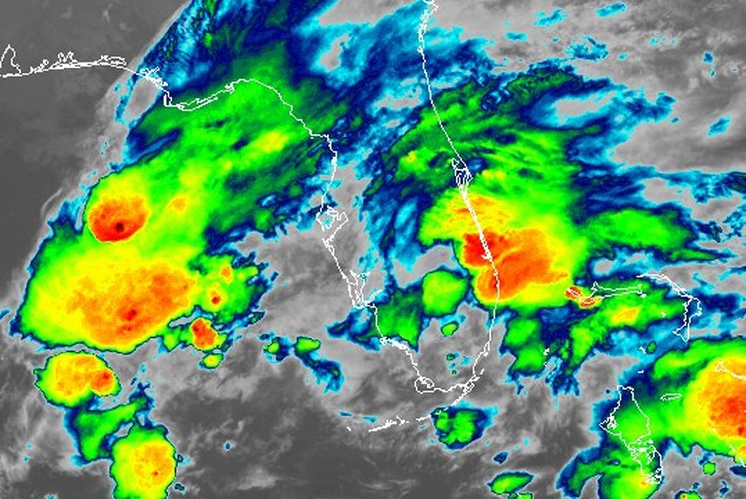
A GOES-19 infrared image received by the Space Coast Wire shows the cold, tall storm tops over Brevard at 11 a.m. Monday, as NWS reported 15 to 20 inches of rain in the southeast of the county.
Written with AI assistance, with sources linked below.
Local Weather
Measured on Brevard's beachside by our own weather station
- Wind
- 3 mph SSW, gusts 6 mph
- Rain today
- 0.12 in
- Humidity
- 88%
- Pressure
- 30.08 inHg ↑ rising
Updated 9:17 PM ET
Our station's outlook (based on local readings, not an official forecast)
Flood Warning in effect: rain on radar near Brevard now. NWS Melbourne, until Wed 11:00 AM ET.
Based on readings to 9:17 PM ET. Rules: 3- and 12-hour pressure change, wind shift and humidity/dew point trend. For official forecasts and warnings see the National Weather Service in Melbourne.
Sun
Sunrise 6:36 AM · Sunset 5:37 PM
Moon
Waning Crescent, 26% lit
Sun and moon times are calculated on our server for Brevard's beachside. Daily weather log, records and forecast →
Confirmed by: National Weather Service Melbourne
This story reflects NWS Melbourne products as of 10:35 p.m. ET Monday. Check NWS Melbourne for the latest alerts.
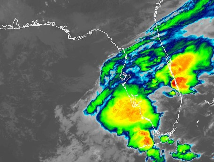
The Space Coast Wire's own satellite dish picked up this view of Monday's storms from NOAA's GOES-19 satellite at 11 a.m. ET. It uses the infrared channel (Band 13), which shows how cold cloud tops are. The reds and oranges are the coldest, tallest storm tops, and the brightest cluster sits over Brevard County.
AI-assisted caption: In this GOES-19 infrared view from 16:00 UTC (11 AM EST) on Nov. 2, the reds and oranges along Florida's east-central coast mark the coldest, tallest storm tops over Brevard County. At 11:35 AM EST, the National Weather Service in Melbourne reported for southeastern Brevard County: "Between 15 and 20 inches of rain have fallen." It declared a "FLASH FLOOD EMERGENCY for West Melbourne, Palm Bay, and Grant-Valkaria." Source: National Weather Service
By then, southern Brevard had been flooding for hours. At 7:56 a.m., the National Weather Service in Melbourne issued a "FLASH FLOOD EMERGENCY FOR WEST MELBOURNE AND PALM BAY". At 11:35 a.m., NWS said "Between 15 and 20 inches of rain have fallen" in southeastern Brevard, added Grant-Valkaria to the emergency and rated the flash flood damage threat "CATASTROPHIC."
AI-assisted caption: The rain over southern Brevard kept piling up all morning, according to National Weather Service Melbourne flash flood warnings received by this dish: "Between 6 and 8 inches of rain have fallen" at 4:44 AM EST, "Between 12 and 15 inches of rain have fallen" at 9:34 AM EST, and "Between 15 and 20 inches of rain have fallen" at 11:35 AM EST. Source: National Weather Service
NWS warnings showed the totals climbing through the morning: "Between 6 and 8 inches of rain have fallen" at 4:44 a.m., "12 and 15 inches" at 9:34 a.m., and 15 to 20 inches by 11:35 a.m.
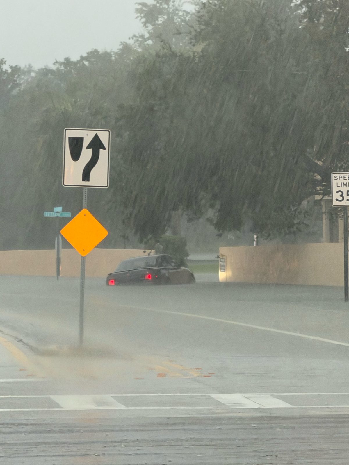
Reports sent to NWS Melbourne Monday morning showed what that looked like on the ground:
- A trained spotter reported flooding near Nebraska Street NE and Rome Avenue NE in Palm Bay, with two vehicles stalled in the water (NWS storm report).
- An NWS employee reported Horizon View Avenue flooded west of West Melbourne, with water "nearly halfway up car tires" (NWS storm report).
- Melbourne police reported a road closure near Sarno Road and Eau Gallie Boulevard because of flooding (NWS storm report).
- Media reported a road closure at Helen Street and Minton Road because of flooding (NWS storm report).
At 1:38 p.m., NWS lowered the emergency to a Flash Flood Warning. The flooding isn't over. At 9:29 p.m., NWS issued a new Flash Flood Warning for southeastern Brevard and north central Indian River County until 11 p.m., saying "Between 14 and 22 inches of rain have fallen" and 1 to 3 more inches are possible. A Flood Warning for southeastern Brevard runs until 9:30 a.m. Tuesday.
For more on Monday's flooding, see our stories on the Flash Flood Emergency, the Flash Flood Warnings, photos of the flooding, Tuesday's school closures and the state of emergency.
Image: NOAA GOES-19, received by SCW Affiliate Jean. Captions marked "AI-assisted" were written with AI help and checked against NWS bulletins. Weather facts: National Weather Service Melbourne.
Sources
- NWS Melbourne Flash Flood Warning, 7:56 AM EST Nov. 2 api.weather.gov/products/df4d0496-fd64-4bcc-b493-fec0a40a6d4b
- NWS Melbourne Flash Flood Warning, 11:35 AM EST Nov. 2 api.weather.gov/products/c8e99e0b-c632-46d2-971d-f8ab1cac1e8d
- NWS Melbourne Flash Flood Warning, 4:44 AM EST Nov. 2 api.weather.gov/products/417cbe7e-e3c7-4c2f-8c92-cf62e5bdecc6
Show all 12 sourcesShow fewer
- NWS Melbourne Flash Flood Warning, 9:34 AM EST Nov. 2 api.weather.gov/products/505e878d-7694-4951-a867-58a83535b180
- NWS Melbourne Flash Flood Warning, 1:38 PM EST Nov. 2 api.weather.gov/products/c208dd5f-f77a-43b1-b295-f43eaeac67a3
- NWS Melbourne Local Storm Report (Palm Bay) api.weather.gov/products/adf353ce-a15a-496b-b033-071579af8ef0
- NWS Melbourne Local Storm Report (Horizon View Ave) api.weather.gov/products/79a67d9f-9f78-443d-bc85-93f2f726536e
- NWS Melbourne Local Storm Report (Sarno Rd) api.weather.gov/products/46636742-a8d6-483b-b93e-bac5fd232b59
- NWS Melbourne Local Storm Report (Helen St/Minton Rd) api.weather.gov/products/8d9f0e98-572a-4b55-b0cf-96d6c98a6b8b
- NWS Melbourne www.weather.gov/mlb/
- NWS Flash Flood Warning, southeastern Brevard, 9:29 PM Nov. 2, until 11 PM api.weather.gov/alerts/urn:oid:2.49.0.1.840.0.e8f67f261867497930b1db2808e2a44df03ab934.001.1
- NWS Flood Warning, southeastern Brevard, until 9:30 AM Tue api.weather.gov/alerts/urn:oid:2.49.0.1.840.0.d5ec6e3e784e6ff98f3e5e84286ac912f718d375.001.1
Spot something wrong? Request a correction · Our standards
Comments
Keep it friendly. Rude, hostile or personal-attack comments will be removed.